14 Aug Tracking water use licences with #MineAlert
Mining your Water project empowers users to track and share water use licences approved for mining, reports Andiswa Matikinca

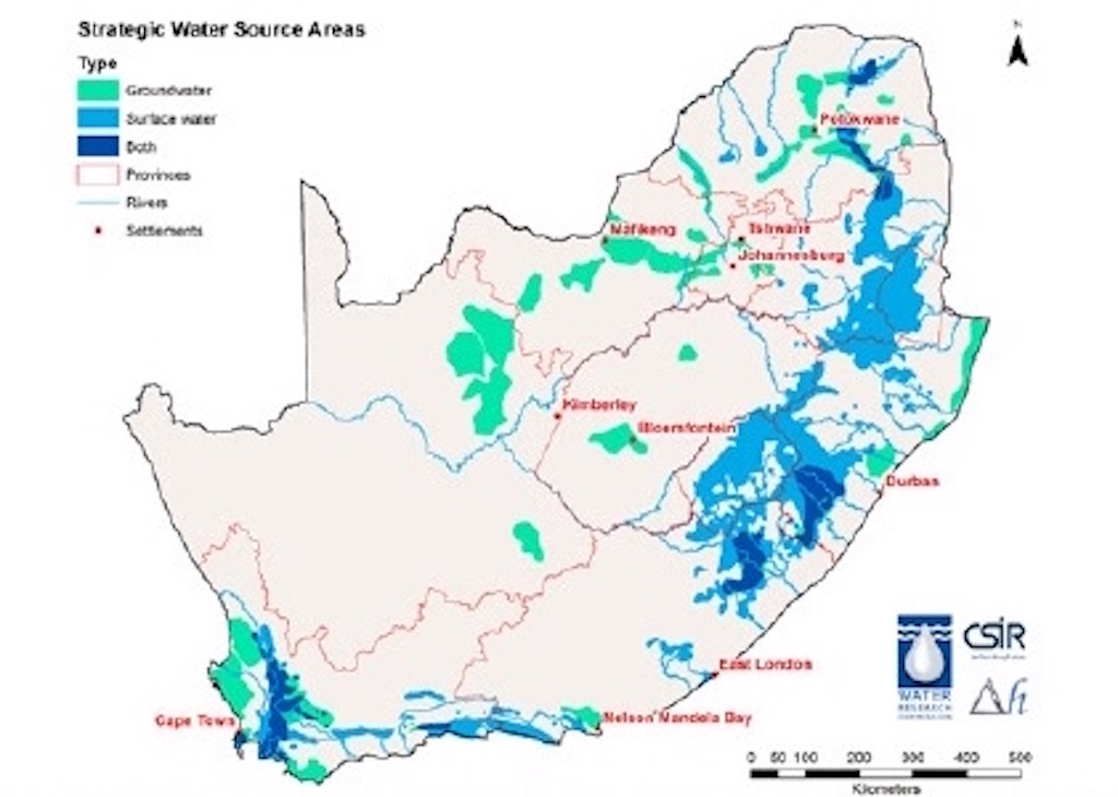
Water factories: South Africa currently has 21 identified strategic water source areas, but only 11% of them receive formal protection. Map sourced
As a country that is considered to be one of the driest countries per capita in the world, South Africa depends greatly on its strategic water source areas. These are natural “water factories”, supporting growth and development needs that are often situated far away.
Strategic water source areas (SWSAs) cover just 8% of the country’s surface but supply 50% of the annual runoff, according to a Water Research Commission report. They supply 50% of the population with water, 64% of the economy and about 70% of the water that is used by agriculture.
Although a total of 21 SWSAs have been identified, only 11% of them receive formal protection. “Deterioration of water quality and quantity in these areas can have a disproportionately large negative effect on the functioning of downstream ecosystems and the overall sustainability of growth and development in the regions they support,” says the report.
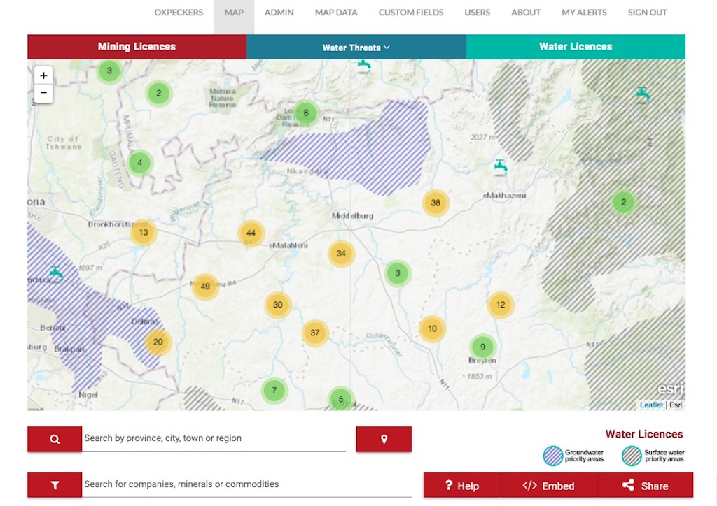
#MineAlert, the Oxpeckers digital tool that empowers users to track mining licences and activities related to mining activities, has launched an additional feature that shares water use licences – and shows where they are situated in SWSAs.
Knowing what conditions and guidelines mining companies should adhere to in terms of water use regulations is a useful way of tracking and understanding the impacts of mining on our water source areas, and of holding the companies to account.
Many communities affected by mining have no prior knowledge that a mine is planned in their area, what the conditions of related licences such as water use licences are, nor how to go about addressing negative impacts.
Although South Africa has laws and processes in place for public participation, people affected by mining struggle to access critical information about what is happening in their backyard. They often don’t know how to seek redress when things go wrong, other than to become angry.
The new #MineAlert Water Licences map, which is part of our Mining your Water project, features data points setting out details of water use licences granted to mining companies, and shows where identified strategic water zones are being affected.
The need to monitor water use applications and licences was emphasised in a recent Oxpeckers investigation that exposed sweeping water permit violations at mines across South Africa. Based on data shared in Parliament by the Department of Water and Sanitation (DWS), the article showed a radical increase in the number of mines flouting water regulations.

Mining your Water: Our new Water Licences map shows which strategic water zones are affected by mining applications and licences, and under what terms
Data trail
A water use licence is the legal authorisation granted by the DWS under the National Water Act to entities that make use of water for any purpose other than basic human needs. The standard licence document includes details of the entity that grants the licence, details of the applicant, properties the application or licence covers, water uses applied for, a description of these activities, general conditions of the licence, and how to appeal the granting of the licence.
#MineAlert decided to start sourcing and sharing water use licences in follow-up to our Water Threats map layers – heat maps that indicate mining risks to South Africa’s ground and surface water reserves. Based on data in the Mine Water Atlas, these maps visualise the general impact of mining on water resources and ecosystems in different parts of the country.
Our new Mining your Water project drills down into data defining strategic water source areas identified in research by the Water Research Commission, WWF South Africa and the Council for Scientific and Industrial Research.
By geolocating water use applications and licences for mines, our new Water Licences map layer helps users to access information on which strategic water zones are being affected by mining activities, and under what terms.
The map currently features more than 470 data points located in eight provinces, and related water use licence documents are shared on our linked sourceAfrica repository. #MineAlert encourages users to create alerts for data points and/or areas that interest and affect them, so you can keep track of developments and updated water licence conditions easily.
Most of the data points are situated in Mpumalanga, home to five SWSAs where coal fields overlap with SWSAs in various locations. These points were collated from a dataset received from the Inkomati-Usuthu Catchment Management Agency after #MineAlert filed a promotion of access to information application to the agency.
The importance of holding coal mines in Mpumalanga to account was highlighted in a recent report by the Centre for Environmental Rights exposing how “gross violations” of water permit regulations by eight coal mines in Mpumalanga are responsible for polluting both surface and underground water resources (See Non-compliance in water use: who takes the blame?).
In the coming months we will be adding more data points to the Water Licences map and sharing applications and licences as we get them. If you have any data or information you would like to share, please sign up to contribute to #MineAlert – or contact us via the platform.
#MineAlert is pioneered by Oxpeckers Investigative Environmental Journalism and ScienceLink, with support from the Open Society Foundation for South Africa and Code for Africa. Water Licences data management assistance was provided by Yuexuan Chen
